|
|
|
9/21/2005 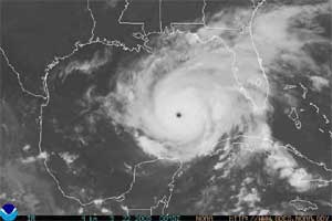
Inland Hurricane WatchSOUTHEAST TEXAS ZONE FORECASTS NATIONAL WEATHER SERVICE HOUSTON/GALVESTON TX 450 PM CDT WED SEP 21 2005 TXZ199-210>212-226-227-221515- MONTGOMERY-COLORADO-AUSTIN-WALLER-WHARTON-FORT BEND- INCLUDING THE CITIES OF...CONROE...THE WOODLANDS...COLUMBUS...EAGLE LAKE...WEIMAR...BELLVILLE...SEALY...BROOKSHIRE... HEMPSTEAD...EL CAMPO...WHARTON...MISSOURI CITY...RICHMOND...ROSENBERG...SUGAR LAND 450 PM CDT WED SEP 21 2005 ...INLAND HURRICANE WATCH IN EFFECT UNTIL THURSDAY EVENING... .TONIGHT...MOSTLY CLEAR. LOWS IN THE MID 70S. SOUTH WINDS 5 TO 10 MPH. .THURSDAY...MOSTLY SUNNY AND UNSEASONABLY WARM. HIGHS NEAR 100. NORTHEAST WINDS 5 TO 10 MPH. .THURSDAY NIGHT...PARTLY CLOUDY. A 20 PERCENT CHANCE OF SHOWERS AND THUNDERSTORMS AFTER MIDNIGHT. LOWS IN THE MID 70S. NORTHEAST WINDS 5 TO 10 MPH. .FRIDAY...PARTLY CLOUDY IN THE MORNING THEN BECOMING MOSTLY CLOUDY. A 50 PERCENT CHANCE OF SHOWERS AND THUNDERSTORMS. BREEZY. HIGHS IN THE LOWER 90S. NORTHEAST WINDS 10 TO 15 MPH IN THE MORNING INCREASING TO 15 TO 25 MPH WITH GUSTS TO AROUND 45 MPH IN THE AFTERNOON. .FRIDAY NIGHT...SHOWERS AND THUNDERSTORMS. TROPICAL STORM FORCE WINDS. LOWS IN THE MID 70S. NORTHEAST WINDS 40 TO 50 MPH IN THE EVENING BECOMING EAST AND INCREASING TO 50 TO 60 MPH WITH GUSTS TO AROUND 75 MPH AFTER MIDNIGHT. CHANCE OF RAIN 90 PERCENT IN THE EVENING INCREASING TO 100 PERCENT AFTER MIDNIGHT. .SATURDAY...SHOWERS AND THUNDERSTORMS. TROPICAL STORM FORCE WINDS. HIGHS IN THE MID 80S. CHANCE OF RAIN 90 PERCENT. .SATURDAY NIGHT...CLOUDY. SHOWERS AND THUNDERSTORMS LIKELY IN THE EVENING...THEN A CHANCE OF SHOWERS AND THUNDERSTORMS AFTER MIDNIGHT. WINDY. LOWS IN THE MID 70S. CHANCE OF RAIN 70 PERCENT IN THE EVENING DECREASING TO 50 PERCENT AFTER MIDNIGHT. .SUNDAY...MOSTLY CLOUDY IN THE MORNING THEN BECOMING PARTLY CLOUDY. A 40 PERCENT CHANCE OF SHOWERS AND THUNDERSTORMS. HIGHS IN THE UPPER 80S. .SUNDAY NIGHT...PARTLY CLOUDY WITH A 30 PERCENT CHANCE OF SHOWERS AND THUNDERSTORMS. LOWS IN THE MID 70S. .MONDAY THROUGH WEDNESDAY...PARTLY CLOUDY WITH A 30 PERCENT CHANCE OF SHOWERS AND THUNDERSTORMS. HIGHS IN THE UPPER 80S. LOWS IN THE LOWER 70S. |
|
| Home | Storms | Astronomy | Travel Pages | Comets | Meteors | Caves | Bio |Contact To
purchase
images contact Christie Ponder Copyright © 1998-2008 [WeatherFriend]. All rights reserved. |